

Geo-Physical Environment
Polangui practically sits on top of one of Bicol Region’s largest watersheds—the Quinali Watershed. It is geographically located close to the central part of the Bicol Peninsula, and far extends to the north bordering Camarines Sur province, down south to the towns of Libon, Oas and Ligao City, westward to the municipality of Malinao and Tabaco City.
Its topography is characterized by steep to very steep slope in the northwestern part encompassing Mt. Masaraga with elongated ridges upper footslopes and high andesitic hills. In the central urban zone and broad alluvial plains, flooding is one of the recurring problems during the wet season and primarily caused by rainfall accumulation, run-off water from elevated areas, and river overflow.
Its climate is characterized to the Type II series which is descriptive of a very pronounced maximum rain period with no dry season. Over the course of the year, Polangui’s temperature varies from 23.88°C to 31.67°C and is rarely below 22.22°C or above 33.33°C.
In 2003, the Bureau of Soil and Water Management (BSWM) identified four (4) pedoecological
zones: lowland (24.33%), upland (49.53%), hilly land (18.68%), and highland (1.44%).
Having a total land area of 145.3 square kilometers covering 44 barangays, Polangui is classified into four (4) general land use categories: (a) agricultural, (b) grassland/shrubland, (c) woodland, and (e) miscellaneous areas.
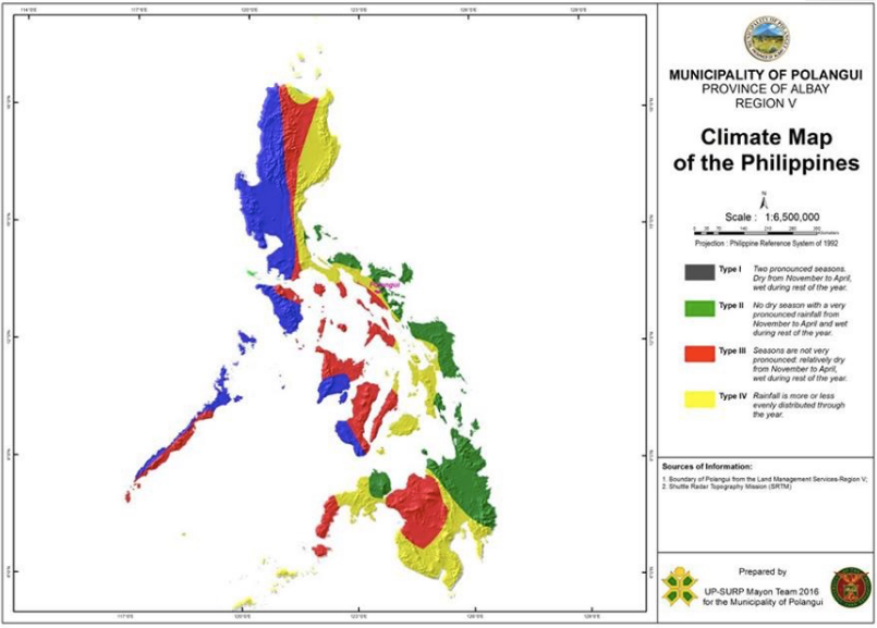
MAP-5: Climate Map of the Philippines
Source: Pagasa.
Geographical Location
Polangui is geographically located in the northern section of Albay Province. It lies between 13°16’40” to 13°22’6” north latitude and 123°23’57” to 123°35’1” east longitude. The Municipality of Polangui is linked to the provincial capital of Legazpi City and other municipalities of Albay along the Pan-Philippine Highway (Daang Maharlika) and cuts through several towns of
Camarines Sur.
It is approximately 552 kilometers south of Metro Manila and can be reached through land travel by bus, train or private vehicle; and by air from Manila or Cebu. It can also be reached by sea berthing at the Tabaco International Seaport, the Legazpi Seaport
and the Pantao Port in Libon, Albay.
Political Boundaries
Polangui is landlocked. It is surrounded in the northwest by the municipalities of Bato and Buhi both of the Province of Camarines Sur. In the east by the municipalities of Malinao, Oas and Tabaco City and in the south-southwest by the municipality of Libon.
The municipality is composed of 44 barangays—16 of which are lowland and partly lowland areas covering 6,773 hectares. Twenty eight (28) barangays are in the upland, hilly and mountainous areas which cover 5,757 hectares.
Topography
Polangui covers a total land area of 145.3 square kilometers (5,757 ha.) Based on WeatherSpark satellite index, the topography of Polangui contains significant variations in elevation, with a maximum elevation of 221.89 meters (728 feet) and an average elevation of 44.80 meters (147 feet) within a 3-kilometer radius. Within the 16-kilometer area contains significant variations in elevation. As of 2003, agricultural land covered about 10,872.3 hectares or 74.82% of the total area utilized for different agricultural activities. The grassland (shrubland) consisted about 2,408.8 hectares or 16.58%, while the woodland cover was estimated at 373.90 hectares or 2.57%. Miscellaneous areas for general land use categories totaled about 875 hectares or 6.02%, per report from the Bureau of Soils and Water Management (BSWM). The map in the follow page shows the topographic base of Polangui.
MAP-6: Polangui Topographic Base Map
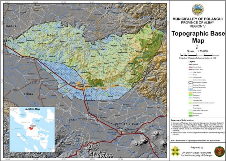
Sources: National Mapping and Resource Information Authority (NAMRIA), DENR-Land Management
Service (LMS), Department of Public Works and Highways (DPWH).